New York, September 4, 2026: The United Nations General Assembly has adopted a series of important resolutions covering global cartographic representation, culture and sustainable development, and the elimination of child, early and forced marriage.
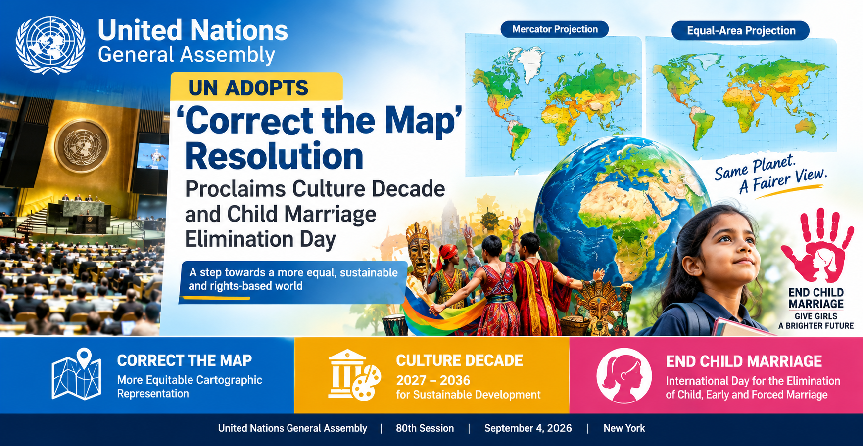
Among the most notable decisions was the adoption of the “Correct the Map: Rebalancing Global Cartographic Representation and Promoting Equitable Representation of the World’s Regions, Particularly Africa” resolution. The Assembly also proclaimed 2027–2036 as the International Decade of Culture for Sustainable Development and approved the establishment of an International Day for the Elimination of Child, Early and Forced Marriage.
UN Adopts ‘Correct the Map’ Resolution
The “Correct the Map” initiative focuses on how the world’s geography is represented through commonly used map projections.
The resolution highlights the importance of more equitable cartographic representation, particularly concerning Africa and other regions whose apparent size can be distorted on certain types of world maps.
The initiative was brought forward by Togo on behalf of the African Group. According to the United Nations, the resolution was adopted with 164 votes in favour, one against and six abstentions.
The discussion has drawn particular attention to the Mercator projection, a map projection developed for navigation that can make areas at higher latitudes appear significantly larger than their actual surface area.
The issue is particularly noticeable when comparing Africa with Greenland. Africa is vastly larger in actual land area, but its size can appear less dramatic on a conventional Mercator-style world map because of the projection’s distortion.
However, the UN resolution does not ban the Mercator projection. Different map projections serve different purposes, and Mercator remains useful for navigation and other applications. The initiative instead encourages greater consideration of alternative projections when the accurate comparison of geographic areas is important.
Why the Map Debate Matters
Maps are not simply geographical illustrations. They are widely used in schools, textbooks, media, government publications, digital platforms and international organisations.
Supporters of the “Correct the Map” initiative argue that the visual representation of countries and continents can influence how people understand the relative size and geographical importance of different regions.
Africa is a particular focus because much of the continent lies closer to the Equator, where some projections produce significant differences between the apparent and actual size of land areas.
The initiative therefore seeks to encourage more appropriate and equitable approaches to cartographic representation, particularly for educational and informational purposes.
Equal-Area Maps Gain Attention
One important concept in the debate is the use of equal-area map projections.
Equal-area projections attempt to preserve the relative size of geographical areas. One example that has received attention in discussions surrounding the issue is the Equal Earth projection.
Unlike the Mercator projection, an equal-area projection is designed to maintain proportional area. However, no flat map can represent the three-dimensional Earth without some distortion. Different projections therefore involve different compromises involving area, shape, distance or direction.
The UN initiative is consequently not about declaring one map projection universally correct. Instead, it encourages the selection of map projections according to their intended purpose.
India and the Global Map Discussion
The resolution also has relevance for India and other countries whose geographical size can look different depending on the projection used.
For educational and general-reference purposes, equal-area maps can provide a more realistic visual comparison of the size of India, Africa, Europe, North America and other regions.
The resolution does not change international borders or territorial claims. It deals with the cartographic representation of geographical areas, rather than changing the political map of the world.
UN Proclaims 2027–2036 International Decade of Culture for Sustainable Development
In another major decision, the General Assembly proclaimed 2027–2036 as the International Decade of Culture for Sustainable Development.
The decision recognises the role culture can play in achieving sustainable development and strengthening cooperation among societies.
Culture is closely connected with education, creativity, innovation, heritage, social cohesion and community development. By dedicating a decade to culture and sustainable development, the UN aims to give greater international attention to these connections.
The initiative is expected to encourage governments, international organisations and other stakeholders to consider cultural dimensions when developing sustainable-development policies and programmes.
New International Day Against Child, Early and Forced Marriage
The General Assembly also adopted a resolution concerning an International Day for the Elimination of Child, Early and Forced Marriage.
According to the UN proceedings, the proposed observance is intended to increase international awareness and strengthen efforts to eliminate child, early and forced marriage.
Child marriage can have serious consequences for education, health, economic opportunities and the overall development and rights of children. Tackling the issue requires effective laws, access to education, economic opportunities, community awareness and sustained government action.
The establishment of an international day is intended to keep the issue on the global agenda and encourage countries and organisations to strengthen measures aimed at protecting children and preventing forced and early marriages.
Three Decisions With a Broader Global Message
The three initiatives adopted by the General Assembly cover very different subjects, but they share broader themes of representation, sustainable development and human rights.
The “Correct the Map” resolution addresses how the world is visually represented and understood. The culture decade highlights the role of cultural development in building sustainable societies. The child-marriage initiative focuses on protecting children and promoting fundamental rights.
Together, the decisions demonstrate the wide range of issues addressed by the United Nations General Assembly.
What Does the ‘Correct the Map’ Resolution Actually Change?
The resolution should not be interpreted as meaning that all existing world maps must immediately be replaced.
It is not a worldwide ban on the Mercator projection, nor does it redraw international borders.
Instead, it promotes greater awareness of cartographic distortion and encourages the use of appropriate projections—particularly equal-area projections—when comparing the size of countries and continents.
Different map projections will continue to be used for different purposes. Navigation, scientific mapping, geographic information systems, education and general reference materials can all require different approaches.
The significance of the UN decision is therefore primarily about how geographical information is represented and communicated, rather than forcing a single replacement map.
Key Facts
Organisation: United Nations General Assembly
Session: 80th session
Date: September 4, 2026
Location: United Nations Headquarters, New York
Major resolution: “Correct the Map: Rebalancing Global Cartographic Representation and Promoting Equitable Representation of the World’s Regions, Particularly Africa”
Vote on map resolution: 164 in favour, 1 against, 6 abstentions
Lead country: Togo, on behalf of the African Group
Main focus: More equitable and appropriate cartographic representation
Mercator projection: Not banned
Alternative discussed: Equal-area projections, including Equal Earth
Culture decade: 2027–2036
Culture initiative: International Decade of Culture for Sustainable Development
Child-marriage initiative: International Day for the Elimination of Child, Early and Forced Marriage
Why This Matters for Readers
For ordinary readers, the “Correct the Map” decision is an opportunity to better understand how maps influence our perception of the world.
A map is always a representation of the Earth rather than the Earth itself. Different projections can make countries look larger, smaller, wider or narrower than they actually are.
The UN initiative draws attention to the importance of choosing the right type of map for the information being communicated. At the same time, the new culture decade and child-marriage observance highlight wider international efforts to promote sustainable development, cultural cooperation and children’s rights.
Habely.com News Desk
This report has been independently written by Habely.com using information from official United Nations records and UN Meetings Coverage. It is not a reproduction of another news organisation’s article.
Primary Source: United Nations General Assembly / UN Meetings Coverage.
Additional official UN source: United Nations General Assembly proceedings and meeting transcripts.